
Картография Navionics
Благодарю. Смотрел эту инструкцию, но изменить цвет получилось только в опции fishing range. Имел в виду можно ли раскрасить сонарчарт в цвета аналогично как в приложении boating?
Choose CHART OPTIONS from your Chart panel and then go to SETTINGS.
For general best display of Navionics charts in your plotter, we recommend the following Settings:
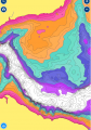
COLORED SEABED AREAS - Used to display different bottom structure in different colors (not available in all areas)
Recommended: User preference (Choice of ON/OFF)
") . В опции карты говорит заходи и тыкай в эту настройку. Другое дело, что в моем случае это on\off ровным счетом ничего не дает.
. В опции карты говорит заходи и тыкай в эту настройку. Другое дело, что в моем случае это on\off ровным счетом ничего не дает.